The most import thing if we talk about accessibility is safety!
Accessibility means being able to reach what matters – work, school, care, shops, people. Mobility is only the means. It is the first question of urban planning, and shall be asked before any money is spent on moving people faster further.
Accessibility is the single most important point in urban planning, and it is usually the one dealt with last. A city notices that people cannot get where they need to go and reaches for a mobility solution: a new line, a faster road, an app, a fleet. Those are expensive, they take years, and they treat the symptom.
Stewardship governance asks the cheaper question first. Before any investment in moving people further and faster, examine how the distance itself can be reduced – where the destination sits, whether the route is safe and direct, whether the thing people travel for could be where they already are. The same ranking that governs safety measures governs this one: remove the problem where possible, and only buy your way around it once that has been exhausted or ruled out with reasons. This is not an argument against investing in transport. It is an argument against investing in transport before anyone has checked what the journeys are for. An authority that has not measured its accessibility does not know what its mobility budget is buying.
Transport policy measures mobility: how far a person can travel in a given time. What people actually need is accessibility: how many of the places they need can be reached, safely and affordably, in reasonable time. The two are not the same, and they pull in opposite directions more often than is comfortable. Higher speed reads as better access and is almost always presented that way. Over time it does something else. People spend a roughly constant share of their day travelling, whatever the speed available to them – so when journeys get faster, they do not get shorter, they get longer. Housing, shops and workplaces spread out to fill the new radius. Distances grow, car dependence grows with them, and accessibility ends up where it started, on top of a far more expensive system.
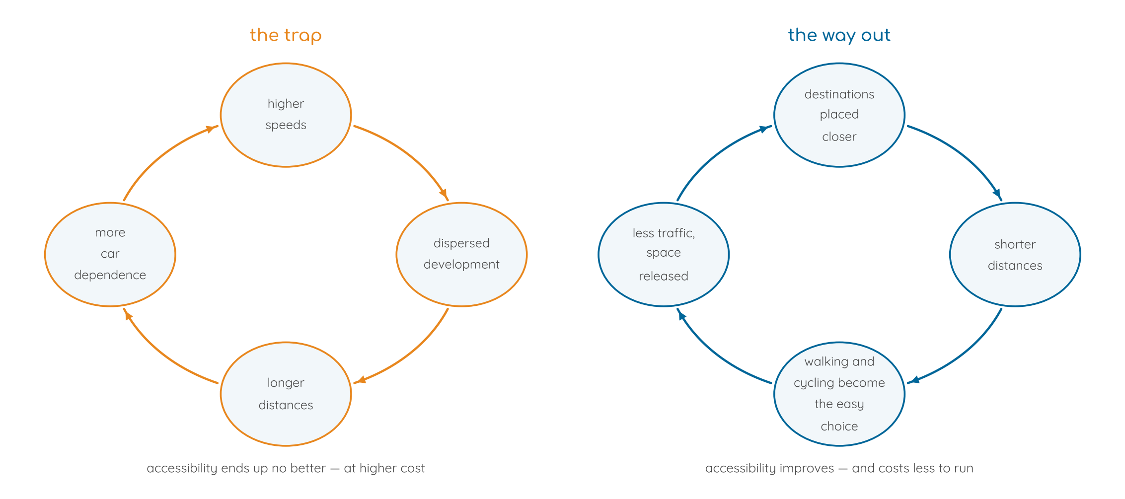
The quantitative accessibility maps now common in planning – how far you can get in thirty minutes – measure the first loop and call it progress. They are useful, and they are not sufficient. What follows from them depends entirely on whether the planner reads a wider circle as success.
why not a 15 minute city
The 15-minute city shares this aim and has done more than anything else to make it widely known. Its weakness is a single time budget for everything. People need some places almost every day and others two or three times in a lifetime. A primary school, a bakery and a bus stop belong in walking distance; a theatre, a concert hall or a university hospital do not, and insisting that they do produces either an unaffordable plan or a theatre too small to be worth going to. Reach is graded by how often a place is needed and by how many people need it – not set at one number for all of them.
how often a place is needed
examplesreasonable standard of accessdailyschool and childcare, groceries, a public transport stop, work where possibleon foot or by bicycle, in a short time and on safe routesweeklydoctor, pharmacy, larger shops, sport and leisureby bicycle, or a short public transport journeyoccasionally or rarelyspecialist hospital, university, theatre, concert hallby good regional public transportA graded standard of this kind is not new in principle. Spatial planning in several European countries already orders central functions by how often they are needed, in the system of central places. What is missing is the link between that hierarchy and a defined standard of access by each mode of travel. Making that link turns accessibility from a general aspiration into something a council can plan for, fund and be held to.
Concrete figures – what counts as a short time, which mode for which tier – are not set here. They depend on the territory, and under the rules of the act an adopted number has to be derived and shown, not inherited from a slogan.
distance is not the whole of it
A destination fifteen minutes away that nobody will cycle to after dark is not accessible. Accessibility is a question of time and distance, and also of four things that a map does not show.
Safety
Whether the route can be used by a child, at night, in the rain, without being mixed with moving traffic. This is where accessibility and the safety field meet, and it is usually the binding constraint.
Convenience
Whether there is somewhere secure to leave a bicycle at the other end, whether the pavement is wide enough for two people and a pram, whether the connection waits for you or leaves two minutes before you arrive.
Affordability
Whether the fare, the membership or the rent nearby is within reach of the people who live there. A sports club priced out of its own neighbourhood has moved, whatever the map says.
Social acceptance
Whether arriving by bicycle or bus is normal in that setting, or marks you out. This is the factor most often left out of transport planning and the one that most reliably decides behaviour.These are assessed qualitatively, destination by destination, and the answers are recorded. The question is not “how far is the clinic” but “can the people who need the clinic actually get there”.
who pays for distance
Sprawl is usually described as an environmental problem. It is at least as much a social one, and a fiscal one. Rents rise in the centre, so those with family and the lowest incomes move to the edge, where connections are poorest, and spend hours a day travelling. Those who can afford a central address have short journeys and keep the time. The people with the least money spend the most of their life in transit – and in a sprawling area they are also the ones who need a car, and therefore carry the highest transport costs on the lowest income. The public cost runs the same way. The more dispersed a settlement, the more it costs to supply – and emergency cover in particular rises steeply, to the point where comprehensive provision cannot be financed at all. Fast help can be guaranteed in an urban setting. Beyond it, longer response times have to be accepted, and the further out people live, the more their own preparedness has to carry them until professional help arrives. That is a legitimate choice for a region to make, but it is a choice, and it belongs in the open alongside the rest.
why this depoliticises
A debate about car-free zones or cycle lanes turns ideological within one meeting. People are for it or against it, the positions are known in advance, and nothing is learned. A debate about whether children can reach their school safely, or whether an elderly resident can reach a doctor without being driven, rarely does. Almost nobody is against better accessibility. Framing the question this way does not resolve every conflict, and it is not a trick for getting unpopular measures through – it simply moves the argument onto ground where evidence counts and where the three groups in a future forum can actually reach consent.
a priority order for street space
Where street space is scarce – and in most places it is – conflicts between uses are decided every day, implicitly, and usually in favour of the vehicle. Stewardship governance asks a council to make the order explicit and then apply it to every street design, every kerb allocation and every conflict. One condition comes before the order and is never traded: the needed space for emergency incident access. This must be a legal obligation, not a preference. Within that condition, space is allocated in this order:
- walking and cycling, including safe crossings and places to stop and rest
- public transport and public service mobility, including on-demand services that meet the service standard
- services of general interest – care, social services, the supply of public facilities
- climate adaptation – trees, shade, unsealed and planted surfaces, space for rainwater
- deliveries, trades and commercial services, in bookable time windows
- private motorised traffic, including commercial and automated fleets serving individual trips
- parking of private vehicles
The order is not new in principle – Brussels plans by the STOP principle, and the UK highway code has carried a hierarchy of road users since 2022. What stewardship governance adds is that a departure from it has to be stated and justified, in the same way as a departure from any other ranking of measures.
emergency access comes first
A street that an ambulance cannot pass is not an accessibility question for later. Every second lost between the emergency call and arrival can decide whether someone survives, and most of the delays that occur in public space are avoidable ones created by design or by a failure to enforce. What has to be kept clear at all times is the approach to the incident location, the access to the building, and the standing areas for appliances, aerial ladders and portable ladders. The requirements are known, they are written down, and they are routinely designed out of existence by parking. This is worked out in full on its own page, including the dimensions, the treatment of street trees, and Safety Lanes – cycle and bus lanes planned from the outset to carry emergency vehicles, which have been shown to shorten response times rather than lengthen them.Properly done, traffic calming and fast emergency access are not in conflict. A London study of the low traffic neighbourhoods introduced in 2020 found no deterioration in fire service response times. What causes the conflict is calming designed without asking the fire service, and that is a process failure, not a trade-off.
baseline 0, applied to accessibility
The zero state here is the one that would be owed: every resident can reach the destinations of each tier, by the mode appropriate to that tier, on a route that is safe and usable by the people who need it. That is the normal condition, not a target. Everything short of it is a gap, stated with the number of people it affects, the destinations concerned, the way that would close it, what that costs and who would have to act. A gap may be carried – a town may decide it cannot afford to close one this decade – but it is carried openly, by a named decision, and it reappears in every report until it is closed or decided again. The practical consequence is an order of work. Measure the street and the reach before anything changes: without a baseline, no later measure can be shown to have worked, and every argument about it becomes an argument about anecdotes.
the challenge of the coming robotaxis
The battle for monopoly control of passenger transport has reached Europe. A handful of US billionaires and Chinese tech giants are sending their robotaxi fleets into our cities. The first pilots in European cities have started. Whoever controls the app, the data and the fleet sets the prices and writes the rules.
Will autonomous fleets become the cash cows of foreign platform monopolies that extract our mobility data and privatise profits?
Or will we organise accessibility as part of public service?
We have seen this before. E-scooters arrived in cities and since then, cities, federal states, operators and police have been trying to regulate them piece by piece: parking zones here, speed limits there, bans in some cities. Meanwhile scooters block pavements and endanger people walking and cycling. And the riders themselves are hurt more every year. In 2025, the police in Germany registered 16 496 e-scooter accidents with injuries, 38 % more than the year before. 38 people died, 1 895 were seriously injured. Almost half of those injured are under 25.
Robotaxis are a different scale. Each vehicle weighs around two tonnes, the fleets will run into thousands, and they are operated by some of the most capital-rich companies in the world. If we regulate them the way we regulated e-scooters, afterwards and bit by bit, the street will be divided up before the rules are written.
This time we know in advance.
The rules can be written before the market is formed.
The street is the largest public space a city owns. It is time to manage it that way.
general problems of passive mobility in cities
streets are still built predominantly for the passive mobility
Most of our streets are built for passive mobility: we sit, and a machine moves us. Private cars, delivery vans and trucks, and soon robotaxis. We know the price. Every year thousands of people die on our roads, and countless more are injured, many of them for life. Exhaust fumes and noise make people ill. And passive mobility makes us passive: too little exercise, declining fitness, obesity, heart disease and diabetes, often starting in childhood. Traffic remains one of the largest sources of climate-damaging emissions. And every square metre of asphalt seals the soil: cities overheat in summer, and heavy rain has nowhere to go. None of this is new. What is less known is how the bill is getting worse and worse.
streets that divide
A busy road cuts a neighbourhood in two. People on one side hardly know those on the other.
Children feel this first. Where traffic is fast and dense, parents no longer let them walk to school, visit friends or play outside on their own. They grow up being driven and watched, and they learn to be independent much later. Yet society and the economy will need exactly that independence from them as adults.
Adults withdraw too. Without squares, quiet streets and places where people enjoy spending time, everyday encounters disappear. More and more people become lonely. And where neighbours no longer meet, it becomes easier to fear the stranger and to give room to hatred.
the money runs out just as the bill grows
Roads, bridges and tunnels are getting older, and the need for renovation keeps rising. At the same time, tax revenue from motorists is falling, as fossil fuel tax shrinks with more efficient and electric vehicles.
The basis of transport finance is eroding on its own, and something will replace it. That is the real decision in front of us.
The gap is paid more and more by the general public, including the many people who do not own a car.
who will drive the bus?
Public transport is the backbone of any mobility transition. Yet bus drivers are retiring faster than new ones can be found. In many regions, timetables are already being thinned out for lack of staff.
from problems to solutions
- fair street pricing – a fair contribution from those who use public space and cause the damage.
- safe city vehicles – vehicles designed to protect vulnerable road users
- public transport – reliable, attractive and on demand, including modular public autonomous vehicles operated as a public service.
- what a city can do now – steps a city can take today, without waiting for new laws.
what a city can do now
None of this requires new legislation. A city can set the conditions for using its own street space today: where automated fleets may stop and what they pay for it, what data comes back, how vehicles must behave towards emergency vehicles, and what a publicly contracted on-demand service has to deliver in return for priority. It can also start the service side now, with drivers, since nothing in a good on-demand network depends on automation.
the solution
A fair street pricing based on the usecase and the space a vehicle occupies and the harm it causes.
- vehicles are rated, not categorised. Mass, footprint, direct vision, acceleration capability, emissions and noise produce the rating the charge is built on.
- active mobility – walking, cycling and public transport pay nothing – as of right, not as a discount.
- the revenue is bound by law to the street the payer can see from their own front door: cycle lanes, crossings, green micro-parks, better transit.
- cities can start now. Curb allocation, parking, access restrictions and procurement are powers most cities already hold. The general Contribution needs new law – and the pilots are what would justify it.
One number shows why this is worth the effort. Calculations for Munich put the hidden public cost at roughly 0,60 € per car kilometre, while every kilometre cycled saves the community about 0,30 €. Moving a single kilometre from car to bike is worth close to 0,90 € – it removes a cost and adds a saving at once.